How Railroad Companies Literally Drew the Lines That Still Define Property Values Today
The Geography of Separation Wasn't Accidental
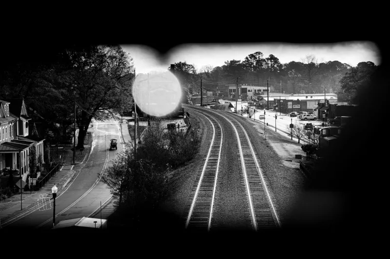
When Americans talk about the 'wrong side of the tracks,' most assume it's a colorful metaphor for economic inequality. But the phrase describes something far more literal — and more consequential — than most people realize. Railroad companies in the 1800s didn't just lay tracks; they engineered social geography that continues to determine property values, mortgage availability, and neighborhood investment patterns today.
The story begins with wind patterns and industrial logic. When railroads arrived in American towns, they brought with them coal-burning locomotives that belched smoke and soot. Railroad companies, working with local planners, deliberately positioned tracks to take advantage of prevailing winds. The wealthy side of town — where company executives, bankers, and merchants lived — was placed upwind from the tracks. Working-class neighborhoods, industrial facilities, and what we'd now call affordable housing were built downwind, where residents would bear the brunt of locomotive pollution.
This wasn't happenstance. It was urban planning with a clear hierarchy built into the blueprint.
How Infrastructure Decisions Became Permanent Boundaries
Railroad tracks created more than just physical division — they established psychological and economic barriers that proved remarkably durable. Banks began using proximity to tracks as a lending criterion. Insurance companies adjusted rates based on which side of the rails properties sat. Local governments directed infrastructure investment — sewers, street lighting, parks — toward the upwind neighborhoods while allowing downwind areas to develop with fewer amenities.
What started as a practical response to 19th-century technology became a self-reinforcing system. Property values on the 'good' side of tracks attracted more investment, better schools, and higher-income residents. The other side became associated with industrial noise, freight traffic, and lower property maintenance — creating exactly the conditions that would justify continued underinvestment.
The tracks themselves often became informal but powerful redlining boundaries, decades before federal housing policies made such discrimination official.
Why the Pattern Outlasted the Trains
Here's what makes this story particularly relevant for today's homebuyers: the geographic advantages that railroads created didn't disappear when locomotives stopped burning coal or when freight routes shifted. The neighborhoods that benefited from being upwind in 1890 had accumulated 50-70 years of superior infrastructure, established wealth, and social networks by the time suburban development began in earnest after World War II.
Meanwhile, areas that had been designated as downwind continued to bear the legacy of their railroad-era positioning. Even when the trains stopped running or switched to cleaner technology, these neighborhoods carried forward decades of deferred maintenance, lower property values, and reduced access to capital.
Modern city planning often reinforces these historical divisions without acknowledging their origin. Highway placement, zoning decisions, and public transit routes frequently follow the same geographic logic that railroads established more than a century ago.
What This Means for Today's Real Estate Market
Contemporary homebuyers navigate a market shaped by decisions made when their great-grandparents were children, but most have no idea they're dealing with inherited geography. When a real estate agent mentions that a property is in a 'transitional' neighborhood or suggests looking 'across town' for better value, they're often unconsciously referencing boundaries that railroad companies drew in the 1800s.
Lending patterns still reflect these historical divisions. Mortgage approval rates, property appraisals, and insurance costs often vary dramatically across neighborhoods that appear similar to modern eyes but carry vastly different historical legacies. A house built in 1950 might be worth twice as much as an identical house built the same year, simply because one sits on the historically favored side of tracks that haven't carried passenger service in decades.
Understanding this history doesn't just satisfy curiosity — it provides practical insight for anyone trying to evaluate neighborhood potential or understand why certain areas seem perpetually 'up and coming' without ever quite arriving.
The Takeaway: Geography Has Memory
The next time you hear someone reference the 'wrong side of the tracks,' remember that they're describing something more precise than economic inequality. They're pointing to a system of geographic advantage and disadvantage that was engineered into American cities and continues to operate largely unchanged.
For homebuyers, this means that neighborhood character isn't just about current amenities or school ratings — it's about inherited infrastructure advantages that may not be immediately visible but continue to influence everything from property appreciation to municipal investment priorities. The tracks that divided towns in 1885 are still dividing property values in 2024, even when the trains are long gone.